Posts

Showing posts with the label family relationships

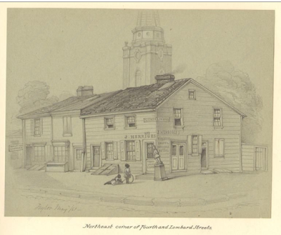
Fig 8 & 8a - J. Herriges Tobacco Building with St. Peter's Church Tower Behind (drawing)
Image
Here is the 1861 and the 1870 drawings of the Herriges' home and retail tobacco store.    Drawing by James E. Taylor, Philadelphia 1861 Taylor Sketchbook or Views of Old Philadelphia. (9.11x7.63in). See the larger photograph at: http://www.historicmapworks.com/Map/US/1600924/ James E. Taylor 1861 drawing from Philadelphia 1861 Taylor Sketchbook or Views of Old Philadelphia   Fig 8: Photo above: Winterthur © The Henry Francis du Pont Winterthur Museum, Inc., Winterthur, DE, USA.       Fig 8a. Photo above: Colorized illustration by Billy D Manus II.   Original black and with illustration, 1870, Charles W. Alexander.  

Fig. 0 & 0 & 9c, 9d:The Union Street Police Station - Map and Photo

Image
Fig 0: Union Street Police Station (in red) Located one block north between Third and Fourth, Spruce and Pine Streets, the Third District Police Station was located on the 300 block.     Copyright, OpenStreetMap Contributors, Open Data Commons Open Database License (ODbL) Photograph was taken by Henry B. Odiorne (1805 - 1860) in August of 1860. Albumen; 22 x 17 cm.(8.75 x 6.75 in.)   Photograph Library Company of Philadelphia .  For a larger image, visit: https://digital.librarycompany.org/islandora/object/Islandora%3A59620     Fig 9c: Property Map   Map credit: OpenStreetMap Contributors Open Data Commons Open Database License (ODbL)   1. Joseph Herriges Land Owned 2. Old Pine Church and Graveyard 3. St. Peter Church and Cemetery (entire block now owned by St. Peter's)   Fig 9d: Property Map 1. Bernard Herriges House and Tobacco Shop 2. Other property owned by Joseph Herriges 3. Soap Manufacturing Plant 4. St. Peter's Church 5. Old ...